
Monday, 12 January, 2026г.


Где искать: по сайтам Запорожской области, статьи, видео ролики
пример: покупка автомобиля в Запорожье
SketchUp Terrain Tutorial Part 1
 У вашего броузера проблема в совместимости с HTML5
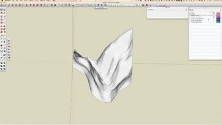
In part I of this tutorial, I'm demonstrating how to pull in terrain from Google Earth using the "Geo-Locate" feature of SketchUp, and then from that imported terrain create contour lines and a new terrain surface from those contour lines using the SketchUp sandbox tools. The contour lines then become the basis for laser cutting a physical model, which is covered in Part II.
Похожие видео
Мой аккаунт