
Saturday, 17 January, 2026г.


Где искать: по сайтам Запорожской области, статьи, видео ролики
пример: покупка автомобиля в Запорожье
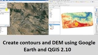
Create contours and DEM using Google Earth and QGIS 2.10
 У вашего броузера проблема в совместимости с HTML5
This video demonstrates, step by step, how to create contour lines and DEM ( Digital Elevation Model) using free tools: Google Earth, TCX Converter and QGIS 2.10.
You know that QGIS can generate DEM and contours from a points cloud which contains altitude information.
So, we used the Path tool in Google Earth to create the points cloud and we exported them to a KML file.
Then, we used TCX Converter to get altitude data of the points (internet connection needed) and export them to a CSV file.
Finally, we imported the CSV in QGIS 2.10 and we used SAGA tools to generate a DEM and contour lines.
-------------------------------------------------------------------
You can download TCX Converter here: http://www.tcxconverter.com/TCX_Converter/includes/downloadtracker.php?Title=TCXConverter_2032_Windows&File=TCX-C-Experience_2032_Windows.zip
For more tutorials, visit our blog : http://monde-geospatial.com/create-contours-and-dem-using-google-earth-and-qgis-2-10/
Subscribe to our Channel : https://www.youtube.com/channel/UCNLNPBubG4enF16-QC5KzWA?sub_confirmation=1
Теги:
google earth qgis qgis2.10 qgis2.8 qgis 2.10 dem contour contours contour lines gis Digital Elevation Model arcgis TCX Converter tcx create generate extract kml csv altitude elevat
Похожие видео
![[QGIS] การสร้างข้อมูลเวกเตอร์ประเภทเส้น (How to create line vector in QGIS)](/images/mq/1/57/dgeJWdT07wtL2c.jpg)
Мой аккаунт