
Sunday, 18 January, 2026г.


Где искать: по сайтам Запорожской области, статьи, видео ролики
пример: покупка автомобиля в Запорожье
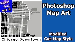
Photoshop Map Art Chicago Downtown - Modified Cut-Map Style
 У вашего броузера проблема в совместимости с HTML5
In this Photoshop Map Art tutorial I will show you how to stylize a map of Downtown Chicago, Illinois. For this map we will use the Modified Cut-Map Style.
**UPDATE: Mapzen closed most services February 1, 2018. So updated shapefiles for Metro-Extracts as well as custom extracts won't be available.
As an alternative, I recommend the open source Hot Export Tool by the Humanitarian Open Streetmap Team. I have made a tutorial on this channel on how get the shapefiles you need with the Hot Export Tool
Hot Export Tool -as replacement for Mapzen Metro Extracts
https://www.youtube.com/watch?v=LACn2bkwljk
I really like the Hot Export Tool. Not only does it allow you to visually expand or shrink the shapefile's boundary, but it allows you to reduce the amount of features to only the ones you choose.
These two advantages allow for efficent shapefiles that are only as large as necessary to get the job done.
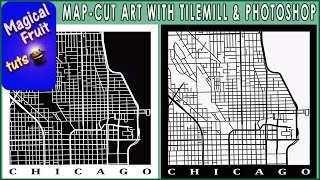
We will use an open source application called TileMill to access Openstreetmap data assembled by Mapzen.com to create a basic map of the downtown business area of Chicago.
After you make the map, you can import it into Photoshop and style it with various colors and layer styles to make map art. Once you finish this tutorial, you can turn your hometown downtown into map art using the Modified Cut-Map Style. Choose your own colors for the land, city, and water and you can make many variations.
Please subscribe to stay informed:
https://www.youtube.com/channel/UCHxb30I2M-RT03jcJOWxQOw?sub_confirmation=1
TileMill Link
https://tilemill-project.github.io/tilemill/
Mapzen Link ( Metro-Extracts currently not available Use Hot Export Tool - https://export.hotosm.org/ )
https://mapzen.com/data/metro-extracts/
Openstreetmap Link
https://www.openstreetmap.org
©OpenStreetMap contributors
licensed under the Open Database License (ODbL)
https://opendatacommons.org/licenses/odbl/summary/
Cartography licensed under the Creative Commons Attribution-ShareAlike 2.0 license (CC BY-SA)
https://creativecommons.org/licenses/by-sa/2.0/
Boundaries central bus dist of chicago
https://www.cityofchicago.org/city/en/depts/doit/dataset/boundaries_-_centralbusinessdistrict.html
Great Lakes Mapping and GIS
http://maps.glin.net
If you want to follow along with the tutorial, here is the Chicago Carto-CSS code used in the TileMill editor for this project. You can copy or paste all or parts of it into Tilemill if you wish.
//Chicago Business District
Map {
background-color: #bbbab8;}
@water:#bbbab8;
#lines [highway='motorway'],
#lines [highway='motorway_link'],
#lines [highway='trunk'],
#lines [highway='trunk_link'],
#lines[highway='primary_link'],
#lines[highway='primary']{
line-width: 2.5;
line-color:white;
line-smooth:1;
line-cap:round; }
#lines [highway='secondary'],
#lines [highway='tertiary'],
#lines [highway='unclassified']{
line-width: 2;
line-smooth:1;
line-cap:round;
line-color:white;}
#lines [highway='residential']{
line-width: 1.5;
line-smooth:1.0;
line-cap:round;
line-color:white;}
#businessdistrict{
polygon-opacity:1;
polygon-smooth:1;
polygon-fill:#70706f;}
#polygons[name='Chicago']{
polygon-opacity:1;
polygon-fill:black; }
#polygons2 [waterway='riverbank']{
polygon-opacity:1;
polygon-fill:@water;}
//Lake and Coast
#coast {
line-color:@water;
line-width:1;
polygon-opacity:1;
polygon-fill:@water; }
This video was made for instructional and educational purposes. In it I teach people how to use Adobe Photoshop to make interesting designs. No copyrighted materials were used in this video.
Теги:
Photoshop Tutorial How to map art map design make a map TileMill Openstreetmap Mapzen Carto CSS Chicago Photoshop Map Art Downtown Chicago City map Map Poster cut-map Modified Cut-Map Style Make a Tilemill map Your Hometown Map with Photoshop Hot Export Tool
Похожие видео


Мой аккаунт