
Monday, 12 January, 2026г.


Где искать: по сайтам Запорожской области, статьи, видео ролики
пример: покупка автомобиля в Запорожье
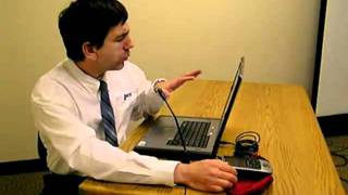
GPS to GIS: Using DNR Garmin to Cable GPS Locations of Field Data to GIS Project: Hardware Focus
 У вашего броузера проблема в совместимости с HTML5
This series of videos describes how to use GPS and GIS in educational instruction--specifically, the whys and hows of gathering field data such as historical buildings, trees, pH in streams, invasive species, social zones on campus, and so on--and then mapping those data to analyze their spatial pattern and assess the issue from a spatial perspective. This video discusses how to connect a GPS to a computer, how to download waypoints and trackpoints, and how to save them as GIS files, along with projection and other issues. The emphasis in this video is on the hardware.
Похожие видео

Мой аккаунт