
Monday, 19 January, 2026г.


Где искать: по сайтам Запорожской области, статьи, видео ролики
пример: покупка автомобиля в Запорожье
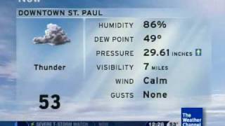
4-15-12 St. Paul, MN TPT Weather Radio (Tornado Watch) 3:45 pm
 У вашего броузера проблема в совместимости с HTML5
The NWS Storm Prediction Center has issued a
Tornado Watch for portions of
extreme northern Iowa
southern Minnesota
west central Wisconsin
Effective this Sunday afternoon and evening from 340 PM until
1100 PM CDT.
Tornadoes...hail to 2.5 inches in diameter...thunderstorm wind
gusts to 70 mph...and dangerous lightning are possible in these
areas.
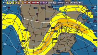
The Tornado Watch area is approximately along and 85 statute
miles either side of a line from 50 miles south southwest of
Redwood Falls Minnesota to 40 miles east southeast of Eau Claire
Wisconsin. For a complete depiction of the watch see the
associated watch outline update (wous64 kwns wou8).
Remember...a Tornado Watch means conditions are favorable for
tornadoes and severe thunderstorms in and close to the watch
area. Persons in these areas should be on the lookout for
threatening weather conditions and listen for later statements
and possible warnings.
Other watch information...continue...ww 177...
Discussion...storms are starting to increase from nwrn IA into swrn
MN in advance of a strong upper trough/vorticity Max moving newd
toward the upper MS valley. Air mass along and south of the warm
front extending across srn MN into wrn WI has warmed during the
afternoon resulting in MLCAPE of 1000-1500 j/kg. Very strong winds
aloft and associated intense vertical shear will aid in storm
organization with potential for supercells to develop...especially
as storms interact with the warm front. Large hail...damaging winds
and a few tornadoes will be possible with stronger cells as activity
gradually spreads/develops newd through the evening hours.
Aviation...tornadoes and a few severe thunderstorms with hail
surface and aloft to 2.5 inches. Extreme turbulence and surface
wind gusts to 60 knots. A few cumulonimbi with maximum tops to
500. Mean storm motion vector 21045.
Похожие видео


Мой аккаунт