
Monday, 19 January, 2026г.


Где искать: по сайтам Запорожской области, статьи, видео ролики
пример: покупка автомобиля в Запорожье
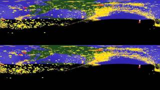
VR visualization of earthquakes beneath Japan
 У вашего броузера проблема в совместимости с HTML5
The version of this video that has been optimized for 360 viewing can be found here: https://youtu.be/Gzxxg6DF0N4 Description: This model shows an area surrounding Japan (between 23.42 and 45.85 lat and 122.78 and 153.58 lon) and 38,451 earthquakes that occurred here between November 8, 1918 and December 16, 2015 (most of the available records are from quakes that occurred after January 1, 1973) shown as scaled spheres. Each sphere is the location of one earthquake hypocenter. This is all of the earthquakes in this area with magnitude 4.0 or greater available from the database made available by the USGS at (http://earthquake.usgs.gov/earthquakes/search/). The camera is positioned at 34.64, 138.18 and travels from 100 km above sea-level to 410km deep before returning in the VR version (there is no vertical exaggeration in this scene). Surface locations of volcanoes active during the holocene from the database made available by the Smithsonian Institution at (http://volcano.si.edu/#) are shown is small, white cones. The purpose of the model is to show the Wadati-Benioff zone where the Pacific Plate to the west is being subducted beneath the Eurasian Plate (north) and Philippine Plate (south) and to communicate processes related to plate tectonics to novice geoscientists. Display/discussion of this or similar models allows for educators and students to use more modern methods to visualize some of the same information (specifically, the distribution of earthquakes, volcanic activity, and sea-floor, bathymetry (which, unfortunately, is difficult to appreciate in this scene)) that the Hess-era pioneers of plate tectonics theory used over half a century ago. It should be particularly useful for novice geoscientists who have not yet developed the skill of immediately reconciling information displayed in map-view and cross-sectional view. Development of this or similar models in an educational context introduces/explores the processes of plate tectonics, global seismicity, volcanic processes, and their related hazards and the skills of developing and interpreting 3D datasets and might be appropriate for a guided activity session in an introductory level physical geology or natural hazards course. For best results, please adjust the video quality to 4K.
Похожие видео

Мой аккаунт