
Friday, 16 January, 2026г.


Где искать: по сайтам Запорожской области, статьи, видео ролики
пример: покупка автомобиля в Запорожье
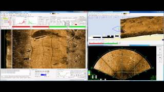
Using a forward look imaging sonar as a nadir gap filler for sidescan data.
 У вашего броузера проблема в совместимости с HTML5
This short video shows a screen capture of the GeoDAS software (Geophysical Data Acquisition System) developed by Oceanic Imaging Consultants, Inc. In this video a BlueView P900-130 2D Forward Look Imaging Sonar is being used as a nadir gap filler for data acquired from the HMS-1400 sidescan sonar. GeoDAS is capable of sampling from a user-defined portion of the forward-look sector; the sampled data gets loaded into the waterfall display, where users are able to define and analyze targets (features of interest). As with sidescan imagery, GeoDAS can also accurately geocode the forward look imagery in order to produce a gap-filled mosaic of the sidescan and forward look imager displayed on top of a chart. For more information about this capability, feel free to visit the OIC website (www.oicinc.com), or contact us at [email protected].
Теги:
Oceanic Imaging BlueView forward look sonar side scan mosaic mosaicking GeoDAS software data acquisition processing AUV ROV gap filler sidescan
Похожие видео


Мой аккаунт