
Friday, 09 January, 2026г.


Где искать: по сайтам Запорожской области, статьи, видео ролики
пример: покупка автомобиля в Запорожье
NASA Catches April 1 Nor’easter over New England
 У вашего броузера проблема в совместимости с HTML5
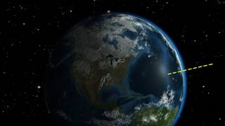
At the time of the Global Precipitation Measurement (GPM) Core Observatory overpass (April 1, 2017, 0550 UTC), the storm's center of low pressure was south of Long Island. At the mid-levels of the atmosphere, the circulation was centered over northeast Pennsylvania. This led to a classic overrunning, warm conveyor setup, which happened when the counterclockwise low level flow drew in cold air out of the north/northeast (hence "Nor'easter") from Canada. Higher up, warm and moist air from further south was lifted over this cold air and resulted in precipitation in the form of snow at the surface. The heavy band of snow that is visible in the GPM data resulted in 8-14 inch totals over southern Maine and New Hampshire, while totals further south in Massachusetts were limited by some mixing with rain.
Music credit: "Flowing with Time," Philippe Lhommet, LOKA Media
This video is public domain and along with other supporting visualizations can be downloaded from the Scientific Visualization Studio at: http://svs.gsfc.nasa.gov/12576
Credit: NASA's Goddard Space Flight Center/Ryan Fitzgibbons
If you liked this video, subscribe to the NASA Goddard YouTube channel: http://www.youtube.com/NASAExplorer
Or subscribe to NASA’s Goddard Shorts HD Podcast: http://svs.gsfc.nasa.gov/vis/iTunes/f0004_index.html
Follow NASA’s Goddard Space Flight Center
· Facebook: http://www.facebook.com/NASA.GSFC
· Twitter http://twitter.com/NASAGoddard
· Flickr http://www.flickr.com/photos/gsfc/
· Instagram http://www.instagram.com/nasagoddard/
· Google+ http://plus.google.com/+NASAGoddard/posts
Похожие видео

Мой аккаунт