
Sunday, 11 January, 2026г.


Где искать: по сайтам Запорожской области, статьи, видео ролики
пример: покупка автомобиля в Запорожье
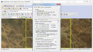
Download large scale image using global Mapper and ArcGis
 У вашего броузера проблема в совместимости с HTML5
to get a large scale image as a perfect base map. The output image will be a Geotiff format to open it by any GIS software. I like to use MapInfo -Discover for applications in the mineral exploration programs.
Теги:
MapInfo_Discover
Похожие видео


Мой аккаунт