
Saturday, 17 January, 2026г.


Где искать: по сайтам Запорожской области, статьи, видео ролики
пример: покупка автомобиля в Запорожье
CATS instrument aboard the ISS studies wildfires from space
 У вашего броузера проблема в совместимости с HTML5
NASA’s Cloud-Aerosol Transport System, or CATS, is a lidar remote-sensing instrument taking measurements of atmospheric aerosols and clouds from the International Space Station (ISS). Launched to the ISS in January 2015, CATS is specifically intended to demonstrate a low-cost, streamlined approach to developing ISS science payloads. The CATS mission extends the data record of space-based aerosol and cloud measurements to ensure the continuity of lidar climate observation.
Data from CATS will help scientists model the structure of dust plumes and other atmospheric features, which can travel far distances and impact air quality. Climate scientists will also use the CATS data, along with data from other Earth-observing instruments, to look at trends and interactions in clouds and aerosols over time.
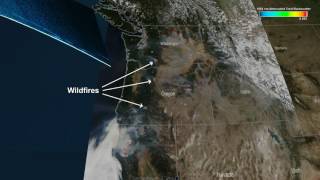
Oregon Wildfires
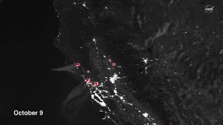
In addition to the aviation industry, fire management and air quality agencies use data from CATS mounted on the ISS. This visualization shows smoke that reached as high as 5 km. from wildfires in Oregon on August 18 2015. CATS has demonstrated the ability to detect the vertical structure of smoke plumes within an unprecedented 6 hour window of data collection.
Accurate monitoring and forecasting of air quality requires these CATS vertical profiles measurements. Smoke plumes from wildfires are common over North America in summer months, causing deadly respiratory illnesses. Aerosols near the Earth’s surface contribute to an annual death toll of 68,000 Americans and 3.3 million people globally. Hurricane Matthew
CATS measurements at different local times over the tropics and mid-latitudes provide comprehensive spatial and temporal coverage of clouds associated with mid-latitude storms and convective systems.
The ISS passes over a region of wildfires in Oregon. Smoke from the wildfires can be seen in attenuated backscatter data collected by the CATS instrument, onboard the ISS.
Visualizer: Kel Elkins (lead)
For more information or to download this public domain video, go to https://svs.gsfc.nasa.gov/4542#69200
Похожие видео


Мой аккаунт