Где искать: по сайтам Запорожской области, статьи, видео ролики
пример: покупка автомобиля в Запорожье
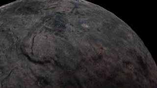
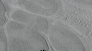
Pluto and Charon in high-resolution simulated flights
 У вашего броузера проблема в совместимости с HTML5
In 2015, NASA’s New Horizons spacecraft made the first close encounter with the Pluto system. These are the first simulated flights over Pluto and Charon made from the highest-resolution black-and-white image strips, taken by New Horizons’ Long Range Reconnaissance Imager (LORRI).
The simulated flight over Pluto starts near the center of the ice sheet and ends on the rugged ice-carved southeastern rim of the basin 500 kilometers away, where the difference between the highest and lowest points is more than 3.5 kilometers. Features as small as about 70 meters are visible on Pluto’s icy, rocky surface. The simulated Charon flyover starts in the low-lying, icy volcanic plains of Vulcan Planitia and ends in fractured northern plains some 500 kilometers away. Prominently visible are several mountains that rise about 3-4 kilometers above the volcanic plains. The images in this narrow strip show surface details as small as about 140 meters across.
Credit: NASA/Johns Hopkins APL/Southwest Research Institute/Lunar and Planetary Institute/Paul Schenk